A study by the Institute of Water and Environmental Engineering (IIAMA) of the Universitat Politècnica de València and the Desertification Research Centre (CIDE, CSIC UV GVA) has developed a methodology that combines crop simulation models with data obtained via drones. The results, published in the journal Computers and Electronics in Agriculture, optimise agricultural yield prediction and water use analysis in high value horticultural crops such as broccoli.
The methodology is based on Aquacrop, a tool developed by the Food and Agriculture Organization of the United Nations (FAO) that evaluates crop water efficiency and projects final yield based on different water availability scenarios. It functions as a kind of virtual laboratory that makes it possible to accurately predict how much a field will produce depending on the water available. "Specifically, Aquacrop OSPy is used, an open source implementation in the Python programming language that reproduces the Aquacrop formulation and facilitates the integration of remote sensing and data assimilation techniques," explains Jesús Huertas, IIAMA researcher and lead author of the study.
The results show that integrating information obtained through drone based remote sensing, particularly data related to crop canopy cover, reduces errors when predicting harvest yields.
Broccoli as a study model
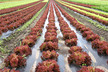
In order to validate the methodology, the researchers conducted a field trial using broccoli over two agricultural seasons on a 0.2 hectare experimental plot located in eastern Spain. The trial compared two different irrigation management approaches, one guided by the decision support system Irrigation Advisor (IA) and the other based on the farmer's experience. This contrast made it possible to assess the margin for improvement offered by technology compared to conventional water management methods.
"This comparison was used to introduce variability and evaluate the model's behaviour under two different irrigation management conditions," notes Diego S. Intrigliolo, CSIC researcher at CIDE (CSIC UV GVA).
During the validation phase, the research team fed Aquacrop software with real data captured by drones during three different flights, including information on crop canopy cover and evapotranspiration, defined as moisture loss through direct evaporation from the soil and plant transpiration via stomata. Regarding yield prediction, integrating these data reduced the RMSE (Root Mean Square Error), an indicator that measures system error, by around 12%. Specifically, the error decreased from 1.67 to 1.47 tonnes per hectare compared to simulations that did not include drone derived information.
In addition, evapotranspiration estimates obtained from thermal images and a Two Source Energy Balance (TSEB) model, which assesses crop water loss based on temperature data captured by drones, showed a high level of agreement with direct field measurements obtained through micro lysimetry, a technique that monitors the water balance in real time under field conditions.
Identifying the most relevant parameters
The study also made it possible to identify, through a global sensitivity analysis, the crop parameters with the greatest influence on canopy cover simulation and yield prediction. This information facilitated model calibration and helped determine which parameters are most informative for the target variables. Once the key parameters were identified, the team adjusted the model in two stages using a hybrid optimisation scheme combining PSO and L BFGS B. This system integrates a global exploration to identify optimal parameters with a local refinement process to ensure accuracy.
"Overall, the results suggest that integrating high resolution observations from unmanned aerial vehicles into crop models can help improve water use diagnostics and yield prediction under Mediterranean conditions," states Miguel Ángel Jiménez Bello, IIAMA researcher and co author of the study.
However, "the conclusions should be interpreted as indicative and require further validation across more seasons, farms, crops and management conditions," adds CIDE researcher Juan Miguel Ramírez Cuesta.
This work was carried out within the framework of the DigitalRiego project, funded by the Valencian Innovation Agency and the European Union through the European Regional Development Fund (ERDF).
Source: csic.es