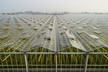
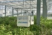
To address perception and navigation challenges in precision agriculture caused by GPS signal loss and weakly structured environments in greenhouses, this study proposes an integrated framework for real-time semantic reconstruction and path planning.
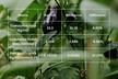
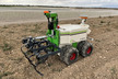
This framework comprises three core components: First, it introduces a semantic segmentation method tailored for greenhouse environments, enhancing recognition accuracy of key navigable areas such as furrows. Second, it designs a visual-semantic fusion SLAM point cloud reconstruction algorithm and proposes a semantic point cloud rasterization method. Finally, it develops a semantic-constrained A* path planning algorithm adapted for semantic maps. Researchers collected a segmentation dataset (1083 images, 4 classes) and a reconstruction dataset from greenhouses in Shanghai. Experiments demonstrate that the segmentation algorithm achieves 95.44% accuracy and 87.93% mIoU, with a 3.9% improvement in furrow category recognition accuracy. The reconstructed point cloud exhibits an average relative error of 7.37% on furrows. In practical greenhouse validation, single-frame point cloud fusion took approximately 0.35 s, while path planning was completed in under 1 s.
Feasible paths avoiding crops were successfully generated across three structurally distinct greenhouses. Results demonstrate that this framework can stably and in real-time accomplish semantic mapping and path planning, providing effective technical support for digital agriculture.
Quan, T.; Luo, J.; Xie, S.; Ren, X.; Miao, Y. Real-Time Semantic Reconstruction and Semantically Constrained Path Planning for Agricultural Robots in Greenhouses. Agronomy 2025, 15, 2696. https://doi.org/10.3390/agronomy15122696
Source: MDPI